In the territory of Tibet, there are more than 20 rivers with a basin area of over 10 thousand square kilometers, and more than 100 rivers have basin areas of over 2000 square kilometers. The famous rivers include the Jinsha River, Nujiang, Lancang River and the Brahmaputra。Tibet has large number of international rivers in, including the upstream section of many famous rivers in Asia such as Ganges River, Indus River, Brahmaputra River, Mekong River, Salween River and Irrawaddy River. The sources of rivers in Tibet are mainly composed of rainwater, melt water and underground water. The rivers are generous and have less sediment concentration and good water quality.
The Yarlung Tsangpo River is the largest river in Tibet, which originates from the Rjema yangzom Glacier within the territory of Zhongba County in the northern area of Himalayas. Its total length within China is 2,057 kilometers and the drainage area is over 240 thousand square kilometers. The average altitude of the drainage area is about 4,500 meters, thus it is the large river with the highest altitude in the world. The lower stream of Yarlung Tsangpo River in India is called Brahmaputra River.
There are over 1,500 various sizes’ lakes in the Tibetan plateau. Namtso, Siling Lake and Tari Namtso are among these lakes, each with more than 1,000 square kilometers. And there are 47 lakes whose areas exceed 100 square kilometers. The total area of these lakes is approximately 24,000 square kilometers, which makes up about one-third of the total lake area in China. Tibet Plateau is not only the largest lake-concentrated area, but also a plateau lake region which has the highest lake, the largest range and the largest number of lakes in the world. There are more salt lakes than freshwater lakes here and 17 lakes are located at an altitude exceeding 5,000 meters.
Due to the high altitude, rarefied air, low dust and moisture content and high transparency, less energy is lost in the process when sunlight penetrates into the atmosphere of Tibetan plateau, resulting in strong radiation. Tibet is the place with the richest solar radiation energy all over the country. Total radiation of Lhasa City is 195 Kcal/Cm²•year, while total radiation of Chengdu is only 88 Kcal/Cm²•year, and Shanghai is 113 Kcal/Cm²•year, all of which have similar latitude. Sunshine duration of Tibet Plateau is also much longer than any other areas with the same latitude in mainland China. For instance, yearly sunshine duration of Lhasa is 3,021 hours, while that of Chengdu and Shanghai are 1,186 hours and 1,932 hours, respectively.
Under the alternative effects of west wind in winter and southwest monsoon in summer, the dry season and rainy season in Tibet are distinctive. Generally, the dry season lasts from October to the following April, while the rainy season is from May to September.
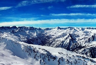
The northwest of Tibet is high, southeast is low, and the elevation drops from around 5,000 meters to a few hundred meters. Therefore, climate type from southeast to northwest is, in order: tropical, subtropics plateau temperate, plateau sub frigid, plateau frigid, and so on. In the alpine and gorge region in southeastern Tibet and southern Himalaya Mountains, air temperature gradually declines as the topography elevates, and climate changes vertically from tropical or subtropical weather to temperate, cool temperate and cold weather. “Four seasons can be seen in a mountain and weather changes in every ten miles” is perfectly embodied here.